RIVER HEIGHTS FOR 1896 and 1897
By ARTHUR P. DAVIS
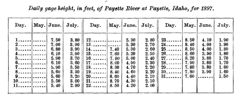
DAILY GAGE HEIGHTS OBSERVED DURING 1896
Department of The Interior WATER-SUPPLY and IRRIGATION PAPERS of The UNITED STATES GEOLOGICAL SURVEY No. 1155th Congress, 2nd Session, HOUSE OF REPRESENTATIVES, Document No. 302
River Heights for 1896 by Arthur Powell Davis
Washington Government Printing Office 1897
The series of tables here presented pertain mainly to the river heights observed and recorded during 1896 by persons employed by or cooperating with the Division of Hydrography of this Survey. There are also included a few tables obtained from the Weather Bureau through the courtesy of Hon. Willis L. Moore, chief of that Bureau. These give the heights of water at points near localities where measurements have been made by hydrographers of this Survey, and are of value in computations of discharge. A few similar tables have been obtained through officers of the Engineer Corps of the United States Army, from observations made in connection with investigations pertaining to the improvement of navigation. There are appended tables of evaporation, seepage, meter ratings, and other similar details to which reference is made by hydrographers of this Survey.
These tables pertain to the progress report of stream measurements for 1896, prepared by the Division of Hydrography and printed in Part IV of the Eighteenth Annual Report of the Survey. They might properly have been included in the progress report, but since they relate to minor details and have a comparatively limited application, it has been thought best, from considerations of economy and from the necessity of reducing the size of the annual report, to include these in a separate publication of more limited distribution. On the other hand, these data should be printed and thus made available for the use of hydrographers, not only those connected with this Survey, but others occupied in similar examinations throughout the country. (Page 7)
Drainage Area Measurement (Page 97)
Payette River at Payette, Idaho Ö.................... 3,565 Square Miles
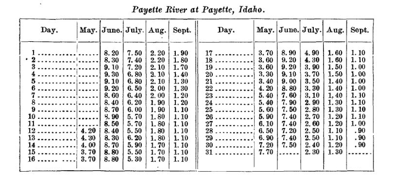
Payette River at Payette, Idaho (Page 83)