Fruitland Downtown Master Plan
History

Prepared for The City of Fruitland
Prepared by PlanMakers


report problem
History
(Page 3)
As its name indicates, Fruitland is the center of one of the most productive fruit growing areas in Idaho. The original townsite was 160 acres, homesteaded by John Hall in 1897. Most of this area was planted in orchards of apples and plums. Irrigation water from the Payette River was provided from the Farmers Cooperative Canal, constructed in 1892-93.

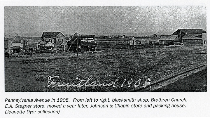
Pennsylvania Avenue in 1908. From left to right, blacksmith shop, Brethren Church, E.A. Stegner store, moved a year later, Johnson and Chapin store and packing house. (Jeanette Dyer collection)

report problem

Zeller's Crossing
(Page 4)
In 1902 Amelia D. Zeller bought the north 80 acres, and with the coming of the Payette Valley Railroad in 1906, the area bore the name Zeller's Crossing. At this crossing, freight was unloaded and the first packing shed was built near the former depot. The first depot burned and was replaced by a simple wood frame gable building located along the tracks between 2nd and 3rd streets. In the early years the train known as the "Punkin Vine" made two round trips a day between Payette and Emmett. Later, one train hauled passengers, freight and mail.

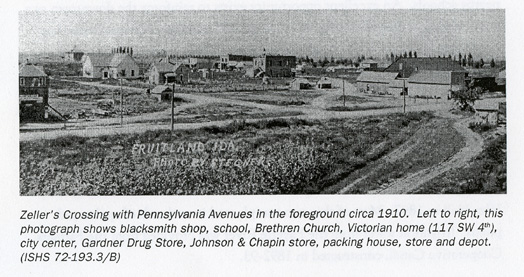
Zeller's Crossing with Pennsylvania Avenues in the foreground circa 1910. Left to right, this photograph shows blacksmith shop, school, Brethren Church, Victorian home (117 SW 4th), city center, Gardner Drug Store, Johnson and Chapin store, packing house, store and depot. (ISHS 72-193.3/B)

The Brainard brothers, real estate dealers, bought in with the Zellers and sold lots. Since the town was surrounded by some of the finest orchards in the valley, B.F. Tussing, an apple grower, coined the name Fruitland. He also named the streets.

report problem

Early Businesses
(Page 4)
Starting in 1906, a number of Fruitland businesses built stores along Pennsylvania Avenue facing the railroad tracks. Early businesses included P.E. Si(u)lkett's blacksmith shop and saloon, E.A. Stegner mercantile store and the Earl Fruit Company. J. O. Johnson and Chapin moved their grocery store from its location across from the Pleasant View Schoolhouse to a site beside the packing house.

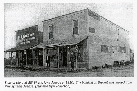
Stegner store at SW 3rd and Iowa Avenue c. 1910. The building on the left was moved from Pennsylvania Avenue. (Jeanette Dyer collection)

The town began to grow, and by 1909 the center of commerce shifted to 3rd Street and Iowa Avenue. Stegner built a new wood two-story store on the corner and moved the original store beside it, joining them together with a door. The store provided groceries, hardware and feed, with Eugene "Gene" Stegner becoming the first postmaster in 1910. The post office boxes were located in the rear of the store. The site is now the school district office. Fortunately, Kenneth Stegner, a son, took a number of early photographs of the growing community. Across the street, still visible on Iowa Street, was the Fruitland State Bank, open from 1910 to 1922 and featuring a public water pump with a trough for horses.

Four two-story brick buildings were built facing the 200 block, joining a number of wood frame storefronts. The former Gardner's Drug features a 45-degree corner entrance and a hall upstairs. Pete Johnson's General Store also had a hall upstairs. Other merchants included J. W. Watkins Cash Store as well as general stores, candy and cigar store, billiard hall and bakery. Fruitland's population in 1913 was 970.


These electronic pages are intended for personal research and may not be reproduced or distributed in any format without the knowledge and written permission of the submitter. Selling or using this information in a commercial venture is strictly prohibited. Any other use, including copying files to other sites, requires permission from the contributors prior to uploading. This page is offered as a courtesy. The USGenWeb Project makes no claims to the validity of the information submitted and believes that each new piece of information should be researched and proved or disproved according to the weight of evidence.


Return to Payette County IDGenWeb Home